Spratly Islands

Written by Kenneth Pletcher
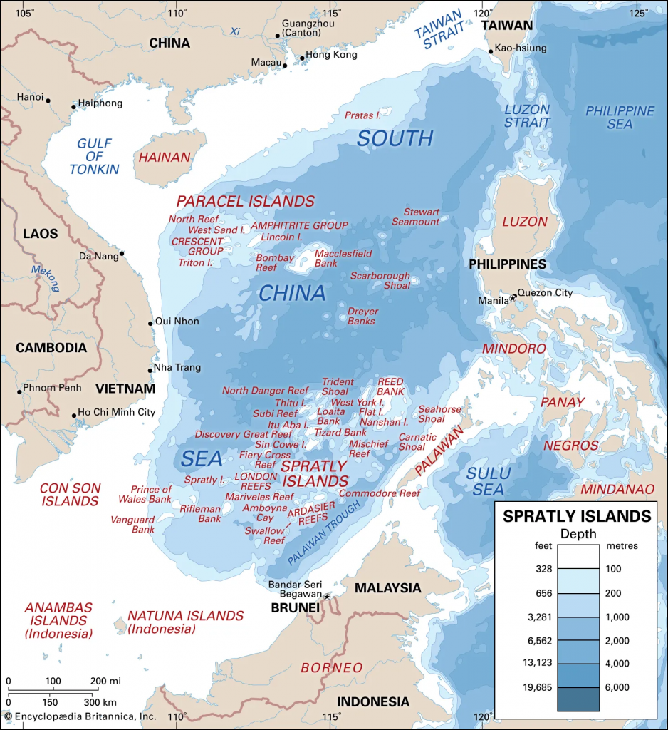
Spratly Islands, Chinese (Pinyin) Nansha Qundao or (Wade-Giles transliteration) Nan-sha Ch’un-tao, Malay Kepulauan Spratly, Pilipino Pangkat Islang Kalayaan, Vietnamese Quan Dao Truong Sa, large group of reefs, shoals, atolls, and small islets in the South China Sea of the Pacific Ocean. They are located north of insular Malaysia and are roughly midway between Vietnam and the Philippines, and they are claimed—wholly or in part—by several countries in the region.
The Spratlys are spread out over a vast area of ocean measuring some 158,000 square miles (409,000 square km). A great number of them are submerged. Of the 12 main naturally occurring islets, the largest is the 90-acre (36-hectare) Itu Aba. Another, called Spratly Island or Storm Island, measures 900 by 1,500 feet (275 by 450 metres). Turtles and seabirds are the only wildlife. There is no permanent human habitation.
Before 1970 the main significance attached to the islands was their strategic location. France held them between 1933 and 1939. During World War II Japan occupied the archipelago and developed it as a submarine base. After the war the Chinese Nationalist government established a garrison on Itu Aba, which the Nationalists maintained after their exile to Taiwan in 1949. When Japan renounced its claim to the islands in 1951, Taiwan, mainland China, and Vietnam all declared themselves the rightful owners, and the Philippines added a claim based on proximity in 1955.
In the 1970s South Vietnam occupied three of the Spratly Islands (including Spratly Island itself) to forestall a Chinese occupation. Troops from Taiwan remained on Itu Aba. The Philippines then moved forces onto seven of the remaining islets and built an airstrip (1976) on Pagasa Island. The United Nations Convention on the Law of the Sea, which came into effect in the early 1980s, established the concept of exclusive economic zones (EEZ) that extended 200 nautical miles (370 km) from a country’s coast. The Spratlys subsequently became considerably more desirable for their potential resources.
By the late 20th century, Vietnam, China, Taiwan, Malaysia (with its occupation of Turumbu Layang-Layang reef [June 1983]), and the Philippines all had conflicting claims to the Spratlys, supported (except, initially, in the case of China) by garrisons on various islands. Although Brunei did not claim any territory in the Spratlys, it did declare an EEZ that contained a Spratly reef. The United States, which has been the dominant presence in the Pacific region for most of the period since the early 20th century, has not recognized the claims of any country on the Spratlys, insisting instead that the Spratlys are in international waters.
China has asserted that its claim to the Spratlys dates back centuries. The Chinese government has stated that almost the entire South China Sea, including the Spratlys and other island groups, is within its sphere of influence. Those claims have been strongly disputed by the Philippines and Vietnam in particular. China first established a presence in the Spratlys in 1988, when its military forcibly removed a Vietnamese garrison from Johnson South Reef. In early 2014 China began intensively building up artificial land on certain reefs and atolls. That activity and China’s stronger statements on its claimed territorial integrity in the Spratlys exacerbated tensions with the United States, which dispatched a U.S. warship through the region in October 2015.U.S. warship through the region in October 2015.
CLICK HERE to read more on “The Spratly Islands” – Wikipedia
CLICK HERE to read “The Spratly Islands Dispute: Who’s On First?” Written by Daniel J. Dzurek
