
The Effects of Climate Change and Sea Level Rise on Dry Season Flows in Tien River and Hau River
Chuc Huynh
Abstract: Tien river and Hau river are two main branches of Cuu Long River which have hydrology regime directly effected by climate change and sea level rise. The flow of the dry season in the Tien and Hau rivers plays a key role in the socio-economic development of the Mekong Delta, especially in agricultural production. The study aims to provide useful information in socio-economic development planning and water use strategies for managers, planners and policymarkers of the provinces/cities in the Mekong Delta. This paper presents the study results in changing of dry season flows in Tien river and Hau river under the impacts of climate change in order to propose measures for protection, substainable development and water security.
Key words: Climate change, sea level rise, dry season flows, Tien river and Hau river.
1. Introduction
MRD (Mekong River Delta) with area of 40,548.2 km2 [1] has two different sea tidal regimes and vast rivers and canals leading to complicated hydrology and hydraulic regimes. MRD plays a strategical position in ecosocial development and also is a main key in national food security strategy. With huge agriculture and aquaculture potentials, MRD accounted for about 53% of total food output, 65% total aquaculture output and 70% total fruit in Vietnam [2].
However, MRD also has many disadvantages of natural conditions impacting on socio-economic development, such as flooding, inudation, saltwater instrusion, alkaline and acid sulphate soil and freshwater shortage for production and domestic activities. Hydrographic regime in the Mekong Delta is directly affected by the upstream flow and East Sea tidal regimes, with semi-irregular tidal regimes, twice the water level up and down in a day. The up-tidal period lasts about 6 hours and down is about 6 hours 45 minutes to 7 hours. The average tidal amplitude varied between 3.0 to 3.5 m in the high water phase. Flood season has the highest three-month average flow of about 30,000-32,000 m3 /s and the dry season with the lowest flow of 2,500-4,000 m3 /s, and average flow of 2,000-2,400 m3 /s in April. Due to the upstream flow combined with intra-field rain and sea tides, freshwater and salt water are mixed in this area. This created rich water environment and ecosystem diversity.
Every year, the dry season in the Mekong Delta is from January to June (about 6 months), with flow regime deeply affected by tides, leading to the complexity of hydrological and hydraulic regimes cause to stilling water phenomena and their distribution in each region. Low flow in dry season causes salt instrusion. Under the impact of CC (Climate Change) and SLR (Sea Level Rise), the Mekong River’s low flow has been impacted severely.
2. Material and Methods
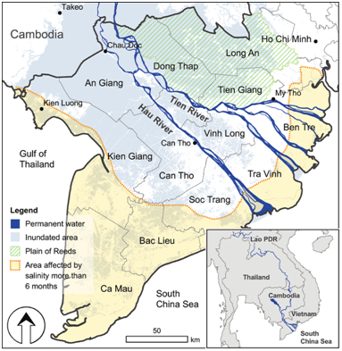
Study area: Hau river and Tien river in the Mekong Delta. The upper boundary of the model is Kratie (Cambodia) and the lower boundary is the estuaries of Tien and Hau rivers (8 gates). The main objective of the study aimed at analyzing and evaluating changes in the dry season flow regime (water level and flow) and the impact of the major factors causing this change. The study methods include synthesis, statistics, analysis, references and modeling [3, 4]. The software MIKE 11 [5] has been applied to simulate hydraulic computation, simulation of change of dry season flow in Tien and Hau rivers. 3. Result and Discussions 3.1 Impacts of Sea Level Rise on the Dry Season Flow of Tien and Hau Rivers 3.1.1 The Current Status of Dry Season Flow of Tien and Hau Rivers The two main hydrological stations to measure the flow are Tan Chau and Chau Doc in the Tien and Hau rivers.
3. Result and Discussions
3.1 Impacts of Sea Level Rise on the Dry Season Flow of Tien and Hau Rivers
3.1.1 The Current Status of Dry Season Flow of Tien and Hau Rivers
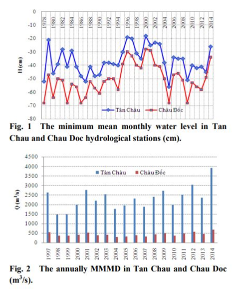
The two main hydrological stations to measure the flow are Tan Chau and Chau Doc in the Tien and Hau rivers. The data of these stations have been analyzed and evaluated. During the dry season, especially on the dryest period (March and April), the backward flow in Tan Chau can reach 3,290 m3 /s (12 April, 1987) and 1,700 m3 /s in Chau Doc (6 April, 1978) due to the effects of tides. The assessment of dry season flow was mainly based on the data of downstream water flows in water use. The downstream water level and flow gradually decreased from the beginning of dry season and the lowest was usually in April, but then it increased slowly. Therefore, the lowest water level has been observed in April.
The minimum mean monthly water level of years was -42 cm in Tan Chau and -38 cm in Chau Doc (4 cm lower than in Tan Chau). The minimum mean monthly water level of the monitoring data was -25 cm (1989) in Tan Chau and -25 cm (1977) in Chau Doc (Fig. 1). The MMMD (Minimum Mean Monthly Discharge) of years is 1,839 m3 /s in Tan Chau and 342 m 3 /s in Chau Doc (Fig. 2). The MMMD of the monitoring data was 1,220 m3 /s (April, 1978) in Tan Chau and 202 m3 /s (April, 1978) in Chau Doc. Thus, the total of MMMD in Tan Chau and Chau Doc was only 1,400-1,500 m3 /s, with the frequency of about 8-10%.
The data of water level showed that the lowest water level was usually in April with the frequency of over 55% in Tan Chau and over 61% in Chau Doc. In May, the frequency of lowest water level was about 38% in Tan Chau and 33% in Chau Doc. In March and April, the discharge is the smallest, mostly in April. According to data from 1997 to 2014, the discharge is smallest in April, accounted for over 83%.
As regards the total volume of water from January to May of Tan Chau and Chau Doc stations, the study showed that the total volume had increased slightly in Tan Chau station and decreased slowly in Chau Doc station. Thus, it should be considered with various aspects to assess dry season flow: the increased water level slightly does not mean that the total amount has increased.
3.1.2 Impacts of SLR on Dry Season in Tien and Hau Rivers
Dry season flows in the Mekong Delta play a very important role in agriculture, especially for winter-spring rice production (R of Hmin and yield is 0.03%) and autuum-summer rice production (R of Hmin and yield is 11.1%) [6]. The MIKE 11 hydrodynamic model was applied to assess the effects of climate change, SLR on the dry season flow in the Mekong Delta. The selected SLR scenarios to assess the water level changes and flows in the Tien and Hau rivers are medium scenario and high scenario [7]. The results in calculating the dry season flow in the Mekong Delta based on climate change and SLR scenarios showed that dry season flows in the Mekong Delta and water level increase or decrease depending on different sites.
The study time was on the dry season with zero rainfall from January to May in the period of 2005 to 2008 to assess the impacts of the dry season flow and forward to 2100 according to the average and high emission scenarios [8].
The results of water level and flow changes in dry season showed that:
For the average scenario with 50 cm sea level rise, the upstream water level in both Tien and Hau rivers has minor varied in comparision with the current status, especially in May. The upstream water level increased the highest by 22 cm and the average by 12 cm in Hau river and the highest of 25 cm and the average of 14 cm in Tien river. The water levels in the middle stream of Tien river and Hau river tended to increase compared to the current status, with the highest of 55 cm and the average of 42 cm in Hau river and the highest of 0.68 m and the average of 62 cm in Tien river. The downstream water levels of Tien river and Hau river tended to increase significantly compared to the current status. It was increased to the highest of 65 cm in Hau river and 68 cm in Tien river.
According to the high scenario, the upstream water levels of both the Tien and Hau rivers tended to slightly decrease as the current status by the end of May. The water levels in the middle and downstream of the Tien and Hau rivers tended to be higher than the current status. The middle stream water level increased the highest by 80 cm and the average by 64 cm in Hau river and the highest of 99 cm and the average of 62 cm in Tien river. The downstream water level increased up to maximum level of 97 cm with the average value of 73 cm in Hau river as well as 98 cm and 74 cm in Tien river, respectively.
The results of water level description showed that most of water levels in the different scenarios were relative high as compared in the downstream, middlestream and upstream of Tien and Hau rivers (Tables 1 and 2).
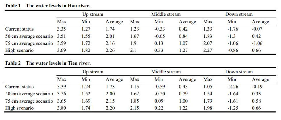
The analysis data of flow change of average and high scenarios in the dry season showed that the discharges of the upstream of both Tien and Hau rivers tended to decrease slightly compared to the current status. The discharges in the middle and down stream of the Tien and Hau rivers tended to be higher than the current status. The discharges of the upstream of the Tien and Hau rivers were likely to decrease in the dry season because the flow from Cambodia is significantly reduced by climate change. In the middle and downstream of the Tien and Hau rivers, water discharge was higher due to the influence of the tide. That combined with sea water rise would make saline water instrusion into the upstream affecting the production and living of people.
3.2 Maintaining Dry Season in Tien and Hau Rivers
The flow of the dry season in the Tien and Hau rivers plays a key role in the socio-economic development of the Mekong Delta, especially in agricultural production. According to the study, the dry season flow in the Tien and Hau rivers would be affected by rising sea levels.
The principle of this measure is that fresh water in the river is stored in the reservoirs for use in saline days. Reservoirs are natural or artificial wetlands near fresh water supplies. The terrains are characterized for this measure as follows:
Death rivers;
Low land terrain;
Artificial reservoirs, formed from embankments (unpaved embankments) of sections of rivers, canals, lagoons … for fresh water storage.
4. Applications
The Mekong Delta is the granary not only for Vietnam but also for other countries. Under the impact of climate change and sea level rise, food security should be considered. The roles of the governments, scientists and related parties in the protection of freshwater resources are vert important to develop agriculture in the Mekong Delta. Surveying and monitoring are also very essential in managing the flow and water levels in the Mekong Delta, but these activities are very expensive. So it is recommended to expand the automatic monitoring stations to obtain data regularly and inexpensively.
References
[1] General Statistics Office of Vietnam. 2011. Statistical Yearbook. Vietnam. [2] Southern Institute for Water Resources Planning. 2012. The Master Plan of Irrigation in the Mekong Delta in Climate Change, Sea Level Rise. Vietnam. [3] Mekong River Commission. 2009. “Hydropower Sector Review for the Joint Basin Planning Process.” Basin Development Plan Programme Phase 2. Vientiane. [4] ICEM (International Centre for Environmental Management). 2009. “National Scoping Consultation Summaries.” The Inception Report Vol III: Mekong River Commission Strategic Environmental Assessment for Hydropower on the Mekong Mainstream. [5] DHI (Danish Hydraulic Institute). 2007. MIKE 11¾River Modelling. Danmark. [6] Vu, T. H. 2014. Research on Extreme Weather Phenomena for Agricultural Development in Dong Thap Muoi. The Final Report of the Institution-level Scientific Project. Sub-institute of Hydrometeorology and Climage Change, Vietnam. [7] Nguyen, P. K. 2009. “Climate Change, Sea Level Rise Scenarios for Vietnam.” Ha Noi: Ministry of. [8] Huynh, C. 2015. Research on the Change of Dry Season Flows in Tien and Hau Rivers in the Mekong Delta and Propose Management Measures. The Final Report of the Ministry-level Scientific Project. Ministry of Natural Resources and Environment, Vietnam.